
What Is Physical Geography? A Complete Guide to Earth’s Natural Features and Processes
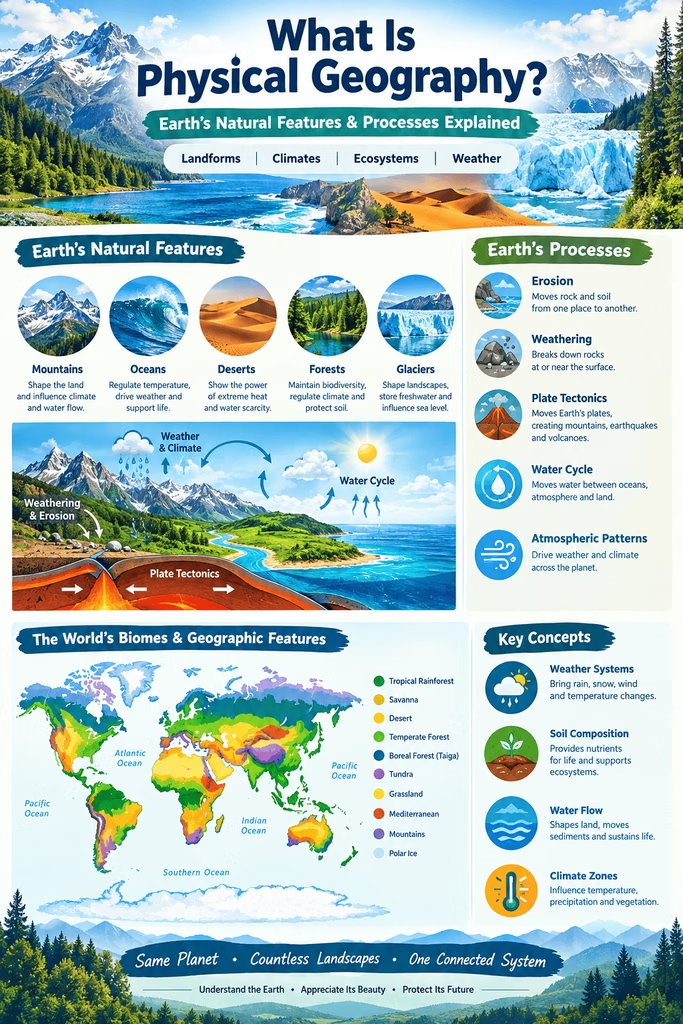
Earth is a complex planet shaped by countless natural processes. Mountains rise above valleys, rivers carve channels through landscapes, glaciers reshape entire regions, and oceans influence weather and climate across the globe. Understanding how these natural features form, change, and interact is an important part of studying our planet.
Physical geography is the branch of geography that examines Earth’s natural environments, physical features, and processes. It focuses on phenomena such as landforms, climate, weather, water, soil, vegetation, and ecosystems. Rather than concentrating primarily on human activities, this field investigates how the natural world works and how different components of the Earth system are connected.
From the movement of tectonic plates to the formation of deserts, the subject helps explain why Earth’s surface looks the way it does. It also provides valuable knowledge for understanding natural hazards, environmental change, resource management, and the effects of climate variability.
Read More: El Niño–Southern Oscillation (ENSO): Causes, Effects, and Global Climate Impact.
What Is Physical Geography?
Physical geography is the study of Earth’s natural features, environments, and physical processes. It investigates the atmosphere, hydrosphere, lithosphere, and biosphere and examines how these systems interact with one another.
The field covers a wide range of topics. These include mountains and valleys, rivers and oceans, weather and climate, soils, glaciers, vegetation, and natural ecosystems. It also explores processes such as erosion, weathering, volcanic activity, earthquakes, flooding, and atmospheric circulation.
A central idea is that Earth’s physical systems are interconnected. For example, rainfall affects river flow, river flow influences erosion, erosion changes landscapes, and the resulting landforms can influence vegetation and human settlement. Studying these relationships allows geographers to understand both individual processes and larger environmental systems.
Read More: What Is Longitude? 11 Positive Facts That Make Geography Easy.
Main Branches of Physical Geography
Because Earth’s natural environment is extremely diverse, the discipline contains several specialized branches. Each branch focuses on a particular part of the Earth system while also considering its connections with other components.
Geomorphology
Geomorphology is the study of landforms and the processes responsible for creating and modifying them. Mountains, plateaus, plains, valleys, dunes, beaches, and river channels are all examples of landforms studied by geomorphologists.
The Earth’s surface is continuously changing. Internal forces, such as tectonic activity and volcanism, can build mountains and other large features. External processes, including weathering, erosion, transportation, and deposition, gradually modify these structures.
For example, a river may erode a valley over thousands or millions of years. Wind can transport sand across a desert and create dunes. Glaciers can carve deep valleys and transport enormous quantities of rock and sediment.
Climatology
Climatology examines Earth’s climate and the long-term patterns of atmospheric conditions. It considers temperature, precipitation, atmospheric circulation, humidity, wind, and other climatic variables.
Climate varies significantly from place to place. Tropical regions generally receive more solar energy throughout the year, while polar regions receive much less. Mountains can also affect precipitation because rising air cools and may produce rainfall or snowfall.
Climatology is especially important for understanding long-term environmental changes. Researchers study historical climate records, atmospheric processes, and climate models to investigate changes in temperature, precipitation, and extreme weather patterns.
Hydrology
Hydrology focuses on water on and beneath Earth’s surface. It includes the study of rivers, lakes, groundwater, glaciers, wetlands, and the movement of water through the environment.
The water cycle is fundamental to hydrology. Water evaporates from oceans and other surfaces, enters the atmosphere, forms clouds, and returns to Earth through precipitation. Some water flows across the surface as runoff, while some infiltrates the soil and becomes groundwater.
Hydrologists study these processes to understand flooding, drought, water availability, groundwater recharge, river systems, and the movement of pollutants through aquatic environments.
Biogeography
Biogeography examines the distribution of living organisms across Earth’s surface. It considers why particular plants and animals occur in certain locations and how environmental conditions influence their distribution.
Temperature, rainfall, elevation, soil characteristics, and habitat availability can all affect where organisms live. Geographic barriers such as oceans, mountains, and deserts may also separate populations.
Biogeography is closely connected to ecology because physical conditions help determine the types of ecosystems that can develop in different regions.
Pedology
Pedology is the scientific study of soils. Soil forms through interactions among rock, climate, organisms, relief, and time.
Different environments produce different soil characteristics. Warm and humid climates may encourage rapid chemical weathering, while cold or dry environments can produce very different soil profiles.
Understanding soil is important because it supports vegetation and agriculture, stores water, cycles nutrients, and provides habitat for many organisms.
Glaciology
Glaciology is the study of glaciers and ice sheets. Glaciers are large masses of ice that move slowly under the influence of gravity.
Glacial movement can dramatically alter landscapes. Moving ice can erode bedrock, transport sediment, and create distinctive landforms such as U-shaped valleys, moraines, and fjords.
Glaciology is also important for studying changes in Earth’s climate because glaciers respond to variations in temperature and precipitation.
Oceanography
Oceanography studies Earth’s oceans and their physical characteristics and processes. Topics include ocean currents, waves, tides, temperature, salinity, and the structure of the ocean floor.
Oceans play a major role in regulating Earth’s climate. They absorb and store large amounts of heat and transport energy through global circulation. Ocean processes also influence weather patterns, coastal environments, and marine ecosystems.
Read More: What Is The Nitrogen Cycle?
The Four Major Earth Systems
A useful way to understand the subject is through four interconnected Earth systems: the atmosphere, hydrosphere, lithosphere, and biosphere.
Atmosphere
The atmosphere is the layer of gases surrounding Earth. It contains mainly nitrogen and oxygen, along with smaller amounts of other gases and water vapor.
Atmospheric processes produce weather and influence climate. Solar energy heats Earth’s surface unevenly, creating differences in temperature and air pressure. These differences contribute to winds and atmospheric circulation.
Hydrosphere
The hydrosphere includes all of Earth’s water. It encompasses oceans, rivers, lakes, groundwater, glaciers, ice sheets, and water vapor in the atmosphere.
Water constantly moves among different parts of the Earth system. This continuous movement is known as the water cycle.
Lithosphere
The lithosphere consists of Earth’s crust and the rigid upper portion of the mantle. It forms the solid foundation of continents and ocean basins.
Tectonic activity within and beneath the lithosphere produces earthquakes, volcanoes, mountains, ocean trenches, and other major geological features.
Biosphere
The biosphere includes the regions of Earth where life exists. Plants, animals, microorganisms, and other living organisms interact with the atmosphere, water, soil, and rocks.
The biosphere is not separate from the physical environment. Instead, living organisms continuously interact with and influence physical processes. Vegetation, for instance, can reduce soil erosion, affect water movement, and influence local climate conditions.
Read More: What Is Latitude Explained Simply
Major Processes Studied in Physical Geography
The natural environment changes through many processes. Some occur rapidly, while others take thousands or millions of years.
Weathering
Weathering is the breakdown of rocks at or near Earth’s surface. It can occur through physical, chemical, or biological processes.
Physical weathering breaks rocks into smaller pieces without changing their chemical composition. Chemical weathering alters the minerals within rocks. Biological weathering occurs when living organisms contribute to rock breakdown.
Temperature changes, water, ice, acids, plant roots, and microorganisms can all contribute to weathering.
Erosion
Erosion is the removal and transportation of weathered material. Moving water, wind, glaciers, and waves are major agents of erosion.
River erosion can deepen valleys and reshape riverbanks. Wind erosion can remove fine sediment from exposed landscapes. Coastal waves can gradually wear away cliffs and beaches.
Deposition
Deposition occurs when transported sediment is dropped or accumulated. It commonly happens when the energy of moving water, wind, or ice decreases.
Rivers may deposit sediment on floodplains and deltas. Wind can create sand dunes, while glaciers can leave behind deposits known as moraines.
Weathering, erosion, transportation, and deposition work together to continuously reshape Earth’s surface.
Plate Tectonics
Plate tectonics explains the large-scale movement of Earth’s lithospheric plates. These plates move slowly over geological time.
Where plates collide, separate, or slide past one another, major geological events can occur. Convergent boundaries may produce mountains, earthquakes, and volcanic activity. Divergent boundaries can create new crust, particularly along mid-ocean ridges.
Plate tectonics is fundamental to understanding the distribution of continents, mountain ranges, volcanoes, and earthquake zones.
Volcanism
Volcanism involves the movement of molten rock and associated materials from Earth’s interior toward or onto the surface.
Volcanic eruptions can create new landforms, release gases and ash, and alter landscapes. Over long periods, repeated volcanic activity can build mountains and islands.
Volcanic materials can also contribute to fertile soils after they weather and break down.
Read More: What Is the Carbon Cycle? 9 Comprehensive Insights That Explain Earth’s Life-Saving System.
Landforms and Their Formation
Landforms are among the most visible subjects in geographical study. They occur in many shapes and sizes, from enormous mountain systems to small coastal features.
Mountains
Mountains can form through tectonic collision, volcanic activity, or other geological processes. Some mountain ranges develop when tectonic plates push against each other and compress Earth’s crust.
Mountains influence climate, water availability, vegetation, and human activities. They can force moist air upward, producing precipitation on one side while creating drier conditions on the other.
Valleys
Valleys are elongated depressions in Earth’s surface. Rivers commonly create V-shaped valleys through erosion, while glaciers can produce broader U-shaped valleys.
Valleys often provide routes for rivers, transportation, agriculture, and human settlement.
Plains
Plains are relatively level areas of land. They may form through sediment deposition, erosion, or geological processes.
Because many plains have relatively gentle terrain and fertile soils, they are often important agricultural regions.
Plateaus
Plateaus are elevated areas with relatively flat or gently rolling surfaces. They can form through tectonic uplift, volcanic activity, or erosion.
Plateaus vary greatly in elevation, climate, vegetation, and geological structure.
Coastal Landforms
Coastal environments contain numerous landforms created by waves, tides, currents, wind, and sediment movement.
Examples include beaches, cliffs, spits, lagoons, barrier islands, sea arches, and deltas. Coastal landscapes can change considerably over time because sediment is constantly being eroded and deposited.
Climate and Weather
Weather and climate are related but distinct concepts. Weather describes atmospheric conditions over relatively short periods, while climate refers to long-term patterns.
Weather can include temperature, rainfall, cloud cover, wind speed, and atmospheric pressure. Climate considers the typical behavior of these variables over much longer periods.
Several factors influence climate. Latitude affects the amount of solar radiation received. Elevation generally influences temperature. Distance from oceans can affect temperature ranges and precipitation. Ocean currents transport heat and can influence coastal climates.
Topography also plays an important role. Mountains can block or redirect air movement and cause differences in precipitation between nearby regions.
Water and the Water Cycle
Water is one of the most important components of Earth’s physical environment. It constantly circulates between the atmosphere, land, oceans, and living organisms.
The major stages of the water cycle include evaporation, condensation, precipitation, infiltration, runoff, and collection.
Solar energy drives much of this cycle. Heat causes water to evaporate, while cooling allows water vapor to condense into clouds. When water droplets or ice particles become sufficiently large, precipitation occurs.
The water cycle connects many geographical processes. Rainfall can cause erosion and flooding, replenish groundwater, feed rivers, and support vegetation.
Read More: What Causes Climate Change? 17 Clear Insights into the Forces Shaping Our Planet.
Ecosystems and Natural Environments
Natural environments are shaped by interactions among climate, soil, water, landforms, and living organisms.
Forests, grasslands, deserts, tundra, wetlands, and other ecosystems develop under different environmental conditions. Temperature and precipitation are particularly important in determining vegetation patterns.
For example, tropical rainforests generally develop in warm regions with abundant rainfall. Deserts typically receive very little precipitation, leading to specialized vegetation and animal adaptations.
Elevation can create environmental zones within relatively short horizontal distances. As altitude increases, temperature and atmospheric conditions change, often producing distinct vegetation zones.
Read More: What Is a Natural Disaster?
Importance of Physical Geography
Studying Earth’s natural systems has practical importance far beyond academic knowledge.
Understanding Natural Hazards
The discipline helps researchers understand earthquakes, volcanic eruptions, floods, landslides, droughts, storms, and other natural hazards.
Knowledge of hazard patterns can help communities identify vulnerable areas and improve preparedness.
Environmental Management
Understanding how water, soil, vegetation, and landforms interact is essential for managing natural resources.
For example, knowledge of erosion processes can help land managers reduce soil loss. Understanding river systems can support better water management and flood planning.
Agriculture
Climate, soil, water availability, and topography strongly influence agriculture. Geographic knowledge helps identify suitable crops and understand environmental limitations.
Farmers and planners can use information about rainfall patterns, soil properties, temperature, and terrain to improve land-use decisions.
Urban and Regional Planning
Cities and infrastructure must be developed with consideration for the physical environment. Floodplains, unstable slopes, coastal areas, and earthquake-prone regions may present particular challenges.
Understanding local terrain and environmental processes can support safer and more sustainable development.
Climate Change Research
The study of climate systems is essential for understanding long-term environmental change. Researchers examine temperature trends, glacier changes, sea-level variations, precipitation patterns, and other indicators.
Geographical knowledge also helps identify how environmental changes may affect ecosystems, water resources, agriculture, and coastal communities.
Physical Geography and Human Geography
Geography is often divided into two broad areas: physical geography and human geography.
Physical geography focuses primarily on natural features and processes, whereas human geography examines human societies, cultures, economies, populations, settlements, and their spatial relationships.
However, the two areas are closely connected.
People live within physical environments and depend on natural resources. At the same time, human activities can modify landscapes, alter water systems, change vegetation, and influence atmospheric conditions.
For example, urban development can replace natural surfaces with roads and buildings, changing drainage patterns and increasing surface runoff. Agriculture can transform vegetation and soil. Deforestation can influence erosion and water cycles.
Therefore, understanding the relationship between natural systems and human activities often requires knowledge from both branches of geography.
Read More: How Do Time Zones Work?
Tools and Methods Used in Physical Geography
Modern geographical research uses a wide range of tools and techniques.
Fieldwork
Fieldwork allows researchers to observe environmental conditions directly. They may measure river discharge, collect soil samples, record weather conditions, map landforms, or study vegetation.
Direct observation provides important information that cannot always be obtained from remote sources.
Maps
Maps are fundamental tools for representing spatial information. Physical maps can show mountains, rivers, elevation, coastlines, and other natural features.
Topographic maps are particularly useful for understanding terrain and elevation.
Read More: What is the Water Cycle?
Geographic Information Systems
Geographic Information Systems, commonly known as GIS, allow researchers to collect, analyze, and visualize geographic data.
GIS can combine information from many sources, such as elevation, rainfall, soil type, land cover, and population distribution. This makes it useful for environmental analysis and planning.
Remote Sensing
Remote sensing involves collecting information about Earth’s surface without directly touching or sampling it. Satellites and aircraft can capture images and other measurements of landscapes and atmospheric conditions.
Remote sensing is useful for monitoring forests, glaciers, coastlines, agricultural areas, clouds, and land-use changes.
Computer Modeling
Computer models allow researchers to simulate environmental processes and explore possible future scenarios.
Models are used in areas such as climate science, hydrology, coastal studies, and natural-hazard research. Although models have limitations, they can provide valuable insights into complex systems.
Read More: Why Do Seasons Change?
Physical Geography in Everyday Life
Although the subject may seem distant from everyday activities, geographical processes influence daily life in many ways.
Weather forecasts depend on knowledge of atmospheric processes. Water supplies depend on hydrological systems. Food production relies on climate and soil conditions. Roads and buildings must account for terrain and geological hazards.
Even decisions about where to build homes, grow crops, establish industries, or protect natural areas can be influenced by geographical information.
Understanding these connections helps people make more informed decisions about their surroundings.
Challenges in Studying Earth’s Physical Environment
Earth’s systems are complex, and many processes operate at different spatial and temporal scales.
A river may change rapidly during a flood but evolve more gradually over thousands of years. A volcanic eruption may occur suddenly, while the mountain it creates can develop over a much longer period.
Researchers must also consider interactions among multiple systems. Climate influences vegetation, vegetation affects soil, soil influences water movement, and water contributes to erosion.
Human activities add another layer of complexity. Land-use change, pollution, resource extraction, and greenhouse gas emissions can alter natural processes.
For these reasons, modern geographical research often involves collaboration among geographers, geologists, climatologists, ecologists, hydrologists, and other scientists.
Future of Physical Geography
The future of the field will increasingly depend on advanced technology and interdisciplinary research.
High-resolution satellite imagery, drones, geographic information systems, automated sensors, and computational models are providing increasingly detailed information about Earth’s environment.
Artificial intelligence and machine learning can also help researchers analyze large datasets, identify environmental patterns, and improve predictions.
At the same time, traditional fieldwork remains important. Measurements collected directly from rivers, glaciers, soils, forests, and other environments help validate observations and models.
As environmental challenges become more complex, understanding how Earth’s systems respond to both natural and human influences will become increasingly important.
Frequently Asked Questions (FAQ)
What is physical geography in simple words?
Physical geography is the study of Earth’s natural features and processes. It examines landforms, climate, water, soil, vegetation, ecosystems, and natural events such as earthquakes and volcanic eruptions.
What are the main branches of physical geography?
Major branches include geomorphology, climatology, hydrology, biogeography, pedology, glaciology, and oceanography. Each focuses on a particular part of Earth’s physical environment.
Why is physical geography important?
It helps people understand natural environments and processes. This knowledge is useful for managing resources, preparing for natural hazards, planning cities, supporting agriculture, and studying environmental change.
What is the difference between physical geography and human geography?
Physical geography focuses mainly on natural features and processes, while human geography examines people, societies, cultures, economies, settlements, and their spatial relationships.
What Earth systems are studied in physical geography?
The major systems include the atmosphere, hydrosphere, lithosphere, and biosphere. These systems continuously interact with one another.
Is physical geography a science?
Yes. It uses scientific observation, measurement, data analysis, fieldwork, mapping, modeling, and other research methods to investigate Earth’s natural environment.
Conclusion
Physical geography provides a comprehensive way to understand Earth’s natural environment. It examines everything from mountains and rivers to climate, oceans, soils, glaciers, vegetation, and ecosystems. More importantly, it investigates the processes that connect these features and cause Earth’s surface and environments to change.
The subject demonstrates that no natural system exists completely in isolation. Atmospheric conditions influence water, water shapes landforms, landforms affect ecosystems, and living organisms interact with soil, water, and climate.
This knowledge has practical value in agriculture, environmental management, urban planning, disaster preparedness, water-resource management, and climate research. As technology provides increasingly detailed information about our planet, the ability to understand and manage Earth’s interconnected systems will become even more valuable.
Ultimately, studying the physical environment helps us understand not only what Earth looks like, but also why it looks that way and how it continues to change. That understanding is essential for making informed decisions about the planet and its future.